Skip to content
Lighthouse Journies- Morant Point Part 1
Capture this.
4 hours of driving on a hot sunny day in the middle of what feels like no where. The only sight as far as the eye can see are green, rolling, sugar cane laden hills. The sweet smell of boiling sugar and molasses from the sugar factory fills the air from more than a mile away. After receiving directions from the kindest security guard at the the sugar factory, we drive towards a sugar cane plateau which eventually flows into a dark green blur some miles away. The hot stickiness of the day can be felt despite our air conditioned car cocoon and the icy bottles of water that keep us hydrated. ‘John crows,’* popular scavenger birds in Jamaica glide and swoop down around us as the wheels of my car take on every pothole and crater on the rocky cartroad like a pro. Rocky is an understatement. The sharp points of the rocks makes this cartroad feel like a very bad vibrating massage. As a country bumpkin, I’ve been on a lot of cartroads in my life but this one is definitely one of the worst. Nothing quite prepares you for the loneliness and fear you experience on this road wondering which will let up first, the endless fields of sugar canes, your patience or your 3 month old car tires. What is clear is that Google maps lied to us because 30 mins easily becomes an hour on this seemingly relentless road.
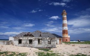
We are on the eastern part of St. Thomas, Jamaica and this is the #LighthouseJourney. Our goal is to make it to Morant Point Lighthouse, the most easterly tip of Jamaica.
 Morant Point Lighthouse
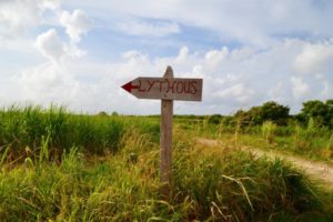
It was March and I started to regret not going to Portland or St. Mary, the ever popular Kingstonian ‘out of town’ spots, on this Ash Wednesday bank holiday. I mean really, which voice in my head convinced me half way through our ‘long route’ journey to Portland that it would be fun to turn off and ‘pop by’ the Morant Point Lighthouse? I’d like to put that voice to rest permanently. This voice got more life as my nature loving mother, who is accustomed to ‘pop by’ meaning 5 minutes in a Barbados context, became thrilled at the idea of visiting the lighthouse. We clearly were befuddled by the sun. Eager like two clueless bunnies, we turned off the ‘good good’ paved road into a lazy country community where even the dogs paused to see who was driving by. You know the type. Those where the memories of colonial Jamaica are bottled into a tight knit 21st century community far away. On Google maps the journey looked so simple. But I should have seen the warning sign that the road had no name and no visible end. The security guard, God bless her soul, made the ‘Lythous’ seem like just a stone’s throw away from the sugar factory. As a country folk myself and having travelled to several ‘deep country’ communities across the Caribbean I should have known better. Country folks never quite give you the right directions and estimations. It’s always an exaggeration or an underestimation; but always, a miscalculation of reality.

Sign at the beginning of the cartroad to Morant Point Lighthouse
As we drove deeper into the sugar canes the eeriness of the moment grew. The reality was suddenly so stark. Two women were driving on a never ending road in the middle of canefields with no civilization in sight. God forbid, if anything were to happen our screams for help would only be heard by God. My mum mumbled something regarding it and stopped mid sentence. Before she even started her sentence I knew what she was going to say. I joked nervously out loud, it’s funny how this journey would be much less nerve rattling if I had brought my partner. I let the psychological thoughts surrounding my statement swirl around my mind in an attempt to distract myself. Beyond one section of the canes, we saw what appeared to be an oasis shrouded with bamboos. It was a welcoming sight in the cane plain that we hoped suggested that we were getting closer to the sea and thus the lighthouse.
The green blur eventually began to take the shape of an expansive mangrove. We breathed a sigh of relief as we were sure now it was only a matter of minutes before we reached the shoreline signalling the eastern edge of Jamaica. How wrong we were ….
*John crow is the turkey vulture (Cathartes aura), also known in some North American regions as the turkey buzzard (or just buzzard), and in some areas of the Caribbean as the John crow or carrion crow. It is a scavenger and feeds almost exclusively on carrion.
 Morant Point Lighthouse
